Analysis by Michael J. Sheldon, Introduction by Andy Carvin
For more than five weeks, the Russian military has rained destruction on cities across Ukraine, making no apparent distinction between civilians and combatants. From Lviv to Luhansk, civilians who are unable to seek shelter or evacuate risk their lives on a daily basis, particularly in the eastern half of the country.
Among the hardest-hit urban areas has been Kharkiv, along Ukraine’s northeastern border with Russia. The country’s second-largest city—and one of its most beautiful—has withstood daily bombardment since the start of the war. Unlike other Ukrainian cities like Mariupul, which Russian forces have besieged to force its surrender, Kharkiv is currently neither surrounded nor being targeted for Russian occupation. Instead, Russia seems to be unleashing artillery, missiles, and rockets on the city as a form of collective punishment.
According to Article 3 of the 1949 Geneva Convention, which establishes the basis for international humanitarian law during war, “Persons taking no active part in the hostilities…shall in all circumstances be treated humanely,” and “violence to life and person, in particular murder of all kinds, mutilation, cruel treatment and torture” are prohibited “at any time and in any place.”
In other words, Russia’s incessant targeting of Kharkiv’s civilian neighborhoods is a war crime.
To better understand the nature of these attacks, the Atlantic Council’s Digital Forensic Research Lab (DFRLab) documented and geolocated more than 140 videos from Kharkiv over a two-week period from March 2 to March 16, 2022. This analysis allowed us to record dozens of incidents in which Russian firepower targeted Kharkiv.
We then visualized the footage of these incidents on the interactive map below to capture the scale of the devastation that Russian bombardment wrought on civilian neighborhoods over the course of fourteen harrowing days. (The map provides an overview of the destruction but is not exhaustive; Russian strikes, for example, also took place prior to the research period and have continued after it as well, and some videos are no longer publicly available.) Click on the red dots to learn more about each incident and explore accompanying video evidence where available, and zoom in and out of the satellite data to get a better sense of the landscape in which these incidents occurred.
How we conducted our research
Over the course of Russia’s war in Ukraine, the DFRLab has monitored hundreds of sources across social media and messaging platforms, including Telegram, TikTok, VKontakte, Twitter, YouTube, and Facebook. Telegram has served as a particularly fertile source of eyewitness accounts, with scores of public channels dedicated to discussing the war.
When a source shares eyewitness footage of a particular incident, the DFRLab analyzes the imagery from a variety of angles, both literally and figuratively. Mapping tools such as Google Earth Pro allow us to explore the geographic environment where an incident allegedly took place, while satellite-imagery services including Planet.com and Sentinel Hub provide the latest overhead imagery. Additionally, we use photogrammetry software such as Meshroom to reconstruct collections of two-dimensional images from an incident into a three-dimensional space. To make a final assessment of what transpired, we also take into account other factors such as weather, time of day, and forensic evidence of the munitions used in the attack. These methods allowed the DFRLab to geolocate 143 pieces of footage, verifying dozens of attacks on residential Kharkiv neighborhoods over the two-week period we studied. Below are some examples of what we found.
Case studies
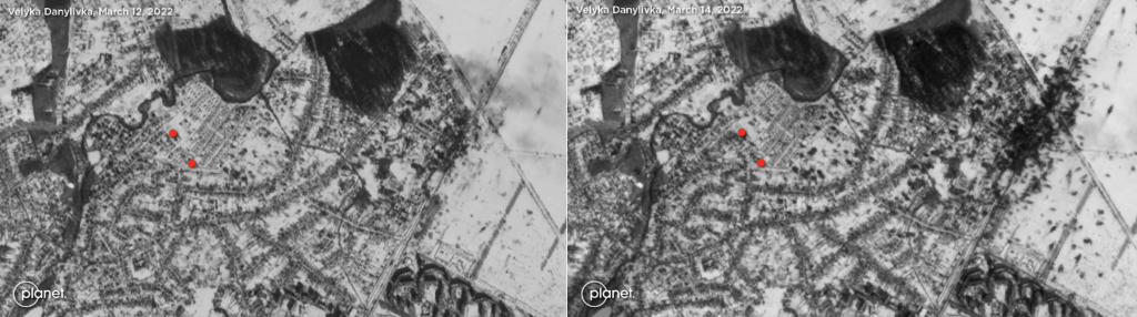
On March 13, a Telegram channel dedicated to Kharkiv uploaded a video showing a Russian multiple launch rocket system (MLRS) firing from the city’s northern suburbs. The video was recorded from a high-rise apartment building in the northern part of Kharkiv’s Saltivka neighborhood, and captured the rockets being fired as well as the impact of them landing in the residential area of Velyka Danylivka.
The quantity of rockets and the frequency of the launches suggested that the system in question was a BM-21 122mm MLRS. Later that day, additional videos from Velyka Danilivka documented fires and destroyed houses at two different locations within the same area. The visible damage suggested the employment of high-explosive munitions, although a definitive line could not be drawn between the observed launches and the damage shown in the subsequent videos.
A comparison between satellite imagery of Velyka Danylivka from March 12 and 14 showed additional artillery impacts in the same area as the geolocated videos. The March 14 imagery appears to show several other new impacts since March 12 in other locations, although some appear to be older impacts made visible by melting snow.
Northern Saltivka, where the first video was recorded, has been one of the hardest-hit neighborhoods in Kharkiv so far in the war. Footage from March 5 showed an apartment building in this neighborhood largely destroyed by artillery fire.
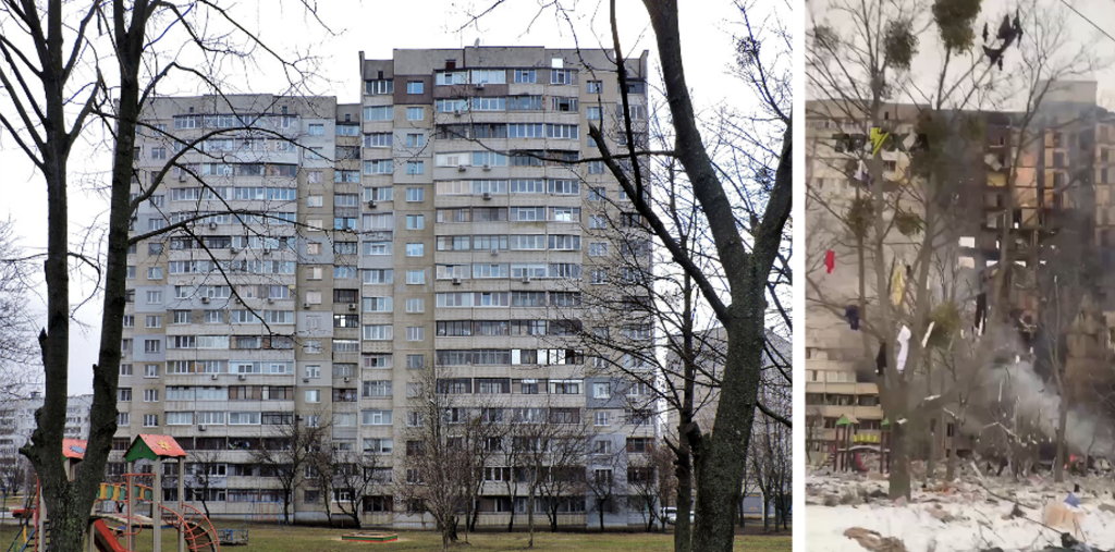
The building was geolocated to 82 Natalii Uzhvii Street, the northernmost street of the neighborhood. Video evidence of the building from multiple angles showed that it was completely destroyed. Apartments that hadn’t entirely collapsed had been completely burnt on the inside.
The city center has also suffered heavy shelling in multiple instances. On March 7, footage emerged of destruction to buildings in the area surrounding the Square of the Heroes of the Heavenly Hundred in central Kharkiv.
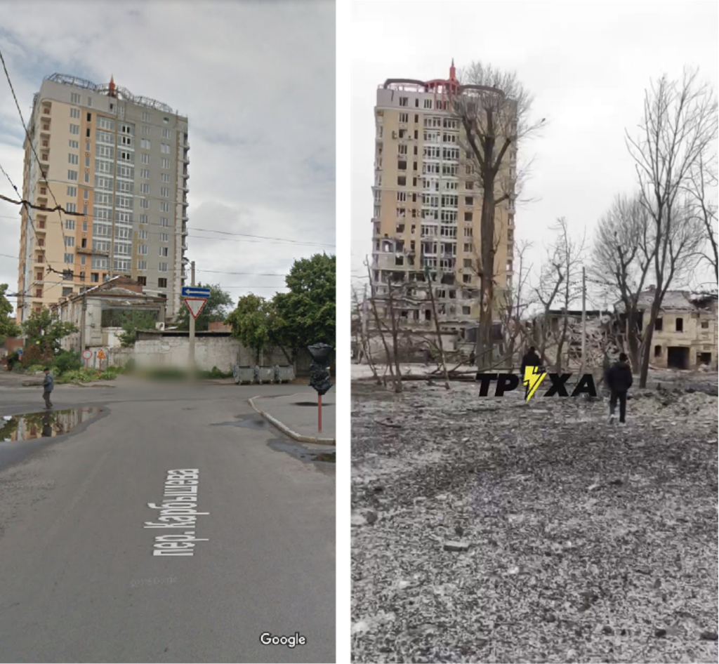
The open-source researcher Karina Nguyen geolocated the above building, adding that the attack occurred on the night of March 6. Several residential houses and businesses were damaged or destroyed during the shelling, including the Kharkiv appellate court.
My friend just sent the video near at their house in Kharkiv, approx. at 7:30 pm local time
— Karina Nguyen (@karinanguyen_) March 6, 2022
Geolocation: 49.988279° 36.244692° @Michael1Sheldon @malachybrowne @christogrozev @ckoettl pic.twitter.com/Q3AbZLxTd5
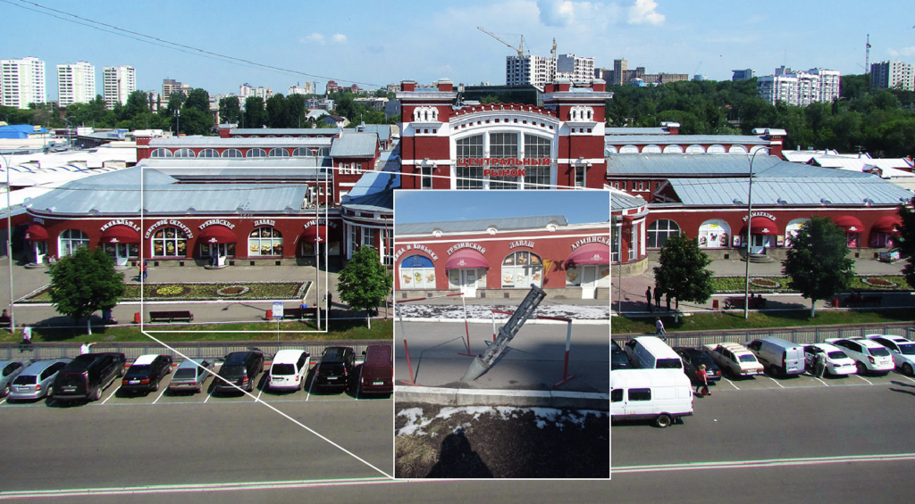
The DFRLab identified several pieces of evidence for the employment of cluster munitions in the city. Cluster munitions, also referred to as submunitions, spray a deadly swath of bomblets across a target area, and have been banned by international convention due to their danger to civilians. On March 15, footage from Kharkiv’s central market documented sections of 220mm 9M27K cargo rockets used for dispersing cluster munitions. That same day, evidence emerged of damage from unknown munitions elsewhere at the market, affecting businesses and cars in the area.
Whether through rockets, missiles, artillery, or aerial bombardment, Russia’s daily attacks have scarred and demolished Kharkiv’s neighborhoods, leaving untold numbers of civilians dead. Because there were eyewitnesses brave enough to record the destruction and share their footage with the world, the documented damage is not merely evident. It is also evidence, which some day might be used to hold Russia accountable for its actions.