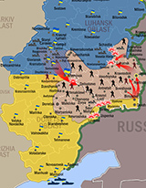
Ukraine’s National Security and Defense Council has issued a map showing what it says are its troops’ latest advances on the battlefield in the two southeastern provinces of Luhansk and Donetsk as of July 9, 2014 (at noon Ukrainian time). The map shows the positions and general movements of its forces against those of the Russian-backed separatist militias commanded by Russian Army Colonel Igor Girkin.
The map, e-mailed to the Atlantic Council by the council’s secretary, Andriy Parubiy, shows Ukraine using all three of its main fighting forces – the army, the province-based National Guard battalions (under the authority of the Interior Ministry) and the State Border Guard Service fighting to control the border zone with Russia, cut off its supplies from across the Russian border, and encircle the separatists in the band of territory between the two provincial capitals, Luhansk and Donetsk cities.