As Russia continues its assault on Ukraine, the Atlantic Council’s Digital Forensic Research Lab (DFRLab) is keeping a close eye on Russia’s movements across the military, cyber, and information domains. With more than seven years of experience monitoring the situation in Ukraine—as well as Russia’s use of propaganda and disinformation to undermine the United States, NATO, and the European Union—the DFRLab’s global team presents the latest installment of the Russian War Report.
Security
Satellite imagery confirms destruction of several Russian aircrafts at Crimea’s Saki airbase
Tracking narratives
Russia spreads “Ukraine sells weapons” narrative again
Satellite imagery confirms destruction of several Russian aircrafts at Crimea’s Saki airbase
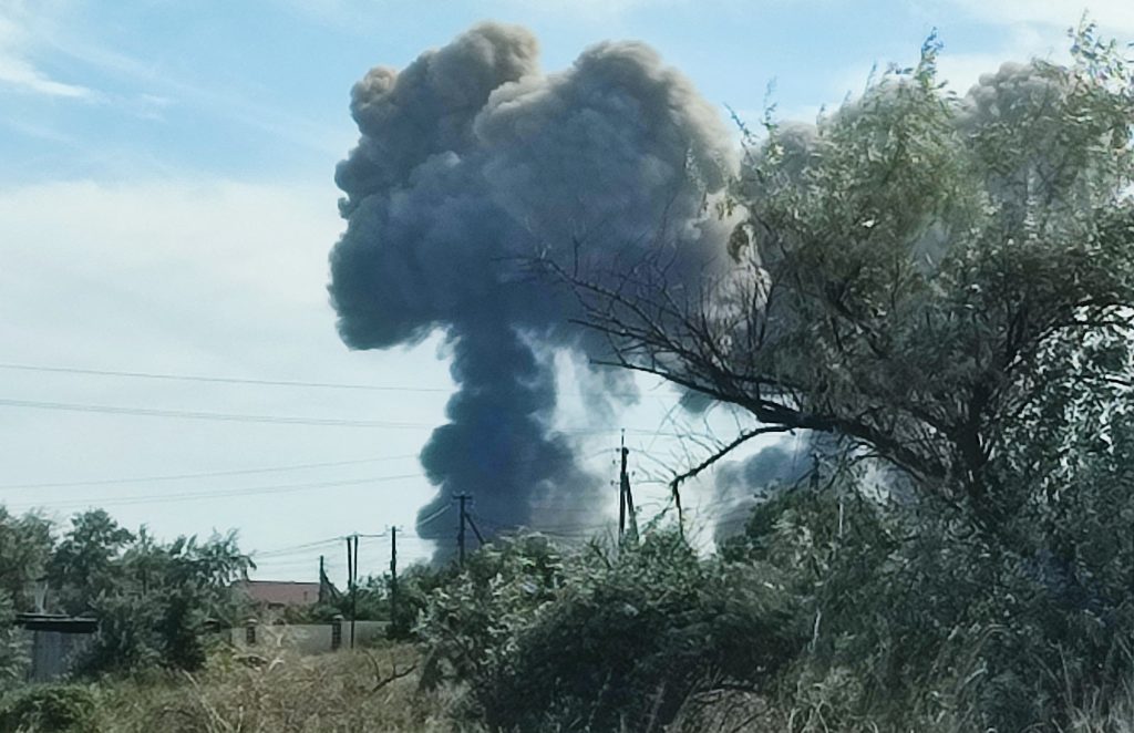
On August 9, two explosions took place at the Saki airbase in Crimea at about 3:20pm local time. Located more than 200 kilometers from the Russia-Ukraine front line, the military airfield hosts the Russian 43rd Separate Naval Assault Air Regiment of the Black Sea Fleet. According to Ukrainian intelligence, Russia has stationed Su-30M and Su-24 fighter aircrafts, along with an Il-76 cargo transporter, at Saki airbase and uses them to launch missile strikes on Ukraine.
At the time of writing, it remained unclear what caused the large explosions at the airfield. On August 9, the Russian Ministry of Defense claimed that aircraft munitions had detonated at a storage facility and that there was no strikes on the airfield. A ministry spokesperson told TASS news agency that the explosion resulted from a violation of fire safety rules. However, volunteers with the mapping collective GeoConfirmed argued that two columns of smoke visible in the footage contradict Russia’s account of events. GeoConfirmed suggested that the distance between the two smoke columns was around 750 meters, which makes it unlikely that an accidental fire could cause two explosions across such a distance. Meanwhile, Ukrainian authorities offered somewhat conflicting explanations about the cause of the explosion. On August 9, the Ukrainian Ministry of Defense argued that it was not able to determine what caused the explosions, while an anonymous Ukrainian government official told the Washington Post that it was an attack carried out by Ukrainian special forces.
Regarding damages and casualties, Sergei Aksyonov, the Russian head of Crimea’s administration, said that 252 people had been placed in temporary accommodation centers after more than sixty apartment buildings and twenty commercial properties in the Novofedorovka settlement were damaged. Aksyonov cordoned off a five-kilometer perimeter around the airbase and declared a “yellow level of terrorist threat” until August 24. Initially, Russia stated that no one was injured as a result of the explosions, but separatist authorities from the Crimean peninsula later reported that one person was killed and nine others were injured. At the time of writing, the official number of victims had increased to fourteen.
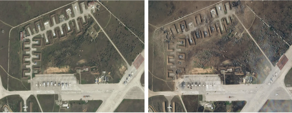
The Russian Defense Ministry also claimed that no aircraft were damaged in the explosion, but satellite imagery contradict this claim. RFE/RL published satellite photos of Saki airbase, taken about four hours before the explosion, showing more than ten airplanes present at the airbase.
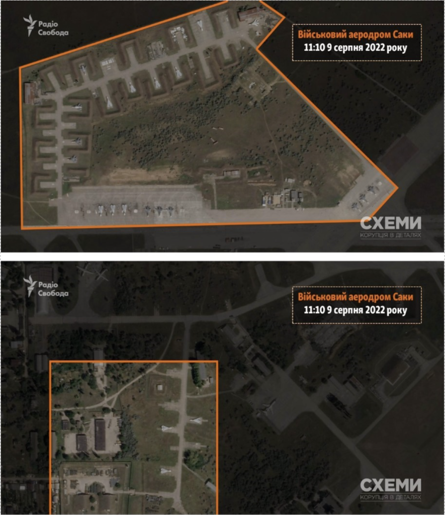
After the explosion, video footage began to circulate on social media showing at least one badly damaged military aircraft, which appears to be a Russian Su-24. On August 10, Planet Labs satellite imagery revealed the scale of destruction caused by the explosion and confirmed that several airplanes were destroyed as a result of the explosions.
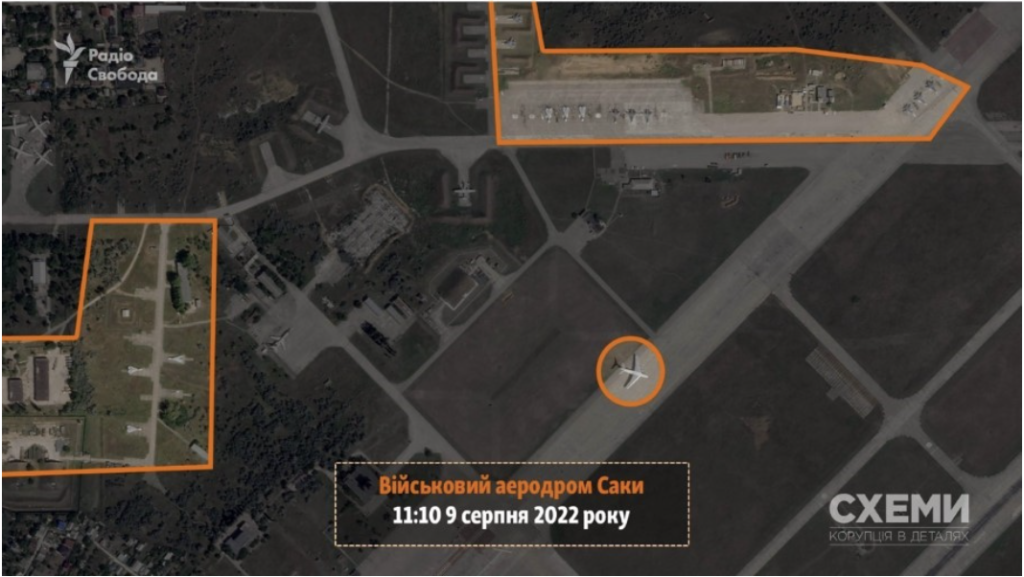
Images from Planet Labs before and after the explosion confirm that multiple aircrafts were damaged. In the below composite, the left image was taken at 11:10 am (Kyiv time) on August 9, and second photo, showing damaged aircrafts, was taken at about 4:40 pm on August 10. The Ukrainian Ministry of Defense reported that Russia lost nine planes on August 9. CNN reported at least seven damaged aircrafts, while the BBC Russian Service, The New York Times and the Institute for the Study of War reported that at least eight aircrafts were damaged. The Ukrainian edition of RFE/RL reported that nine aircrafts were destroyed.
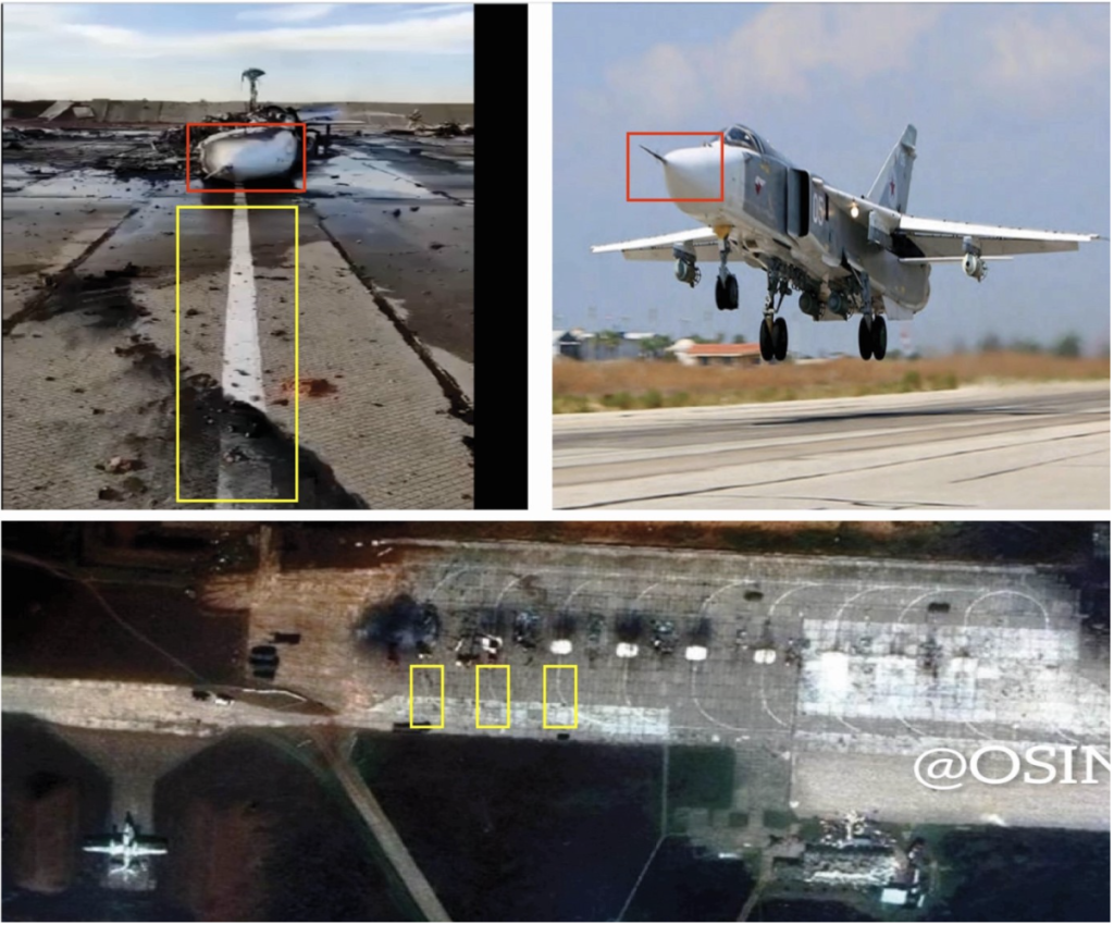
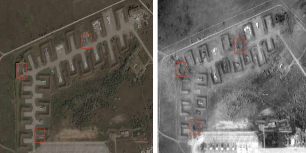
Bellingcat founder Eliot Higgins observed three similar sized craters at storage sites on the airbase. He suggested the aircraft could have been collateral damage after precision strikes from a long-range munition targeted the storage facilities. Higgins also notes that craters are about 20-25 meters wide.
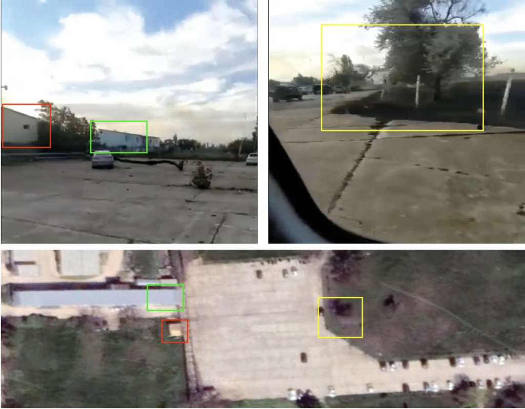
Photos and videos circulating on social media also showed damaged vehicles. One video shows a parking lot with damaged vehicles, located around 600 to 800 meters from warehouses where the blasts took place. The DFRLab used Google Earth to geolocate the car park and confirm that the video was taken at Saki airbase.
—Givi Gigitashvili, Research Associate, Warsaw, Poland
Russia spreads “Ukraine sells weapons” narrative again
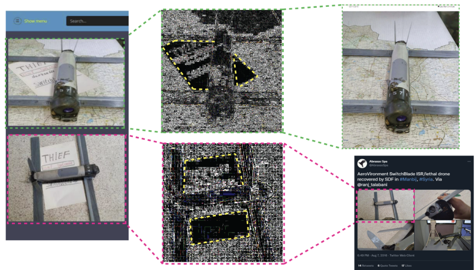
The DFRLab has closely tracked the dissemination through Russian Telegram channels of a debunked narrative that claims Ukraine is selling Western-supplied weapons. In the latest iteration, numerous Russian media sources, including state television, accused Ukraine of selling the Switchblade 300 kamikaze drone on the Dark Web. Initially, the new claim appeared on the pro-Kremlin Twitter account @AZmilitary1 and received amplification from several pro-Kremlin Telegram channels. The message spread across both platforms. The “seller” featured the product on the same platform used in previously debunked attempts to spread this claim.
To prove the ad’s supposed authenticity, the sources provided two screenshots of the drone and one of the delivery details. The drone images feature what appears to be a business card with the name of the seller, the Dark Web marketplace, and the onion router address used to access it. However, both photos were old and repurposed. The only new edit is that the business card was added to the image via editing software.
In the first image, the drone sits atop a map written in Arabic. A reverse image search confirmed that the image was taken and published in Syria on November 3, 2015. Everything from the drone’s serial number to the map is the same. The only difference is the paper, which could be identified as having been replaced after an analysis via the Photo Forensics tool. The second image is from 2016 in Syria and was recognized by StopFake, the Ukrainian fact-checking organization.
The posts also featured a screenshot that claims Europe-wide delivery to increase supposed intimidation and fear from European and American partners. However, as the DFRLab confirmed, the screenshot is taken from another “seller” on the same dark web platform that claims to sell firearms in New York and Kyiv, among other places. The difference in stores could be verified from the URLs that Russian propagandists forgot to edit or crop. This disinformation is in line with the effort of pro-Kremlin sources to undermine Western aid and supply to Ukraine for a few months now.
—Roman Osadchuk, Research Associate
Image: Smoke rises after explosions were heard from the direction of a Russian military airbase near Novofedorivka, Crimea August 9, 2022. REUTERS/Stringer